
 PV Tây Bắc
 ![]() Thứ Bảy, ngày 22/06/2019 20:09 PM (GMT+7)
Thứ Bảy, ngày 22/06/2019 20:09 PM (GMT+7)
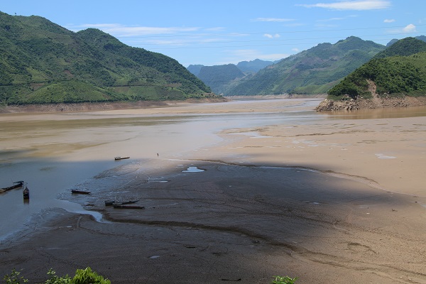
(Dân Việt) Đã hơn 2 tháng nay, người dân dọc 2 bên bờ sông Đà (Sơn La) đang sống trong cảnh đi lại chật vật kể từ khi nước sông Đà rút mạnh, trơ đáy làm giao thông bị ách tắc. Khu vực lòng hồ biến thành bãi bồi, đầy bùn và cát, nhiều phương tiện thuyền, bè bị mắc cạn, không thể lưu thông qua lại.
Đa số người dân sinh sống hai bên bờ sông chủ yếu di chuyển bằng thuyền, bè… Nước sông hạ thấp khiến khoảng cách từ bờ sông ra tới dòng chảy kéo dài hàng trăm mét, đã làm cho việc đi lại của người dân bị đảo lộn.
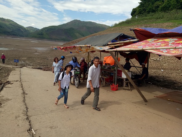
Tại khu vực bến phà Vạn Yên, thuộc xã Tân Phong (Phù Yên) nơi tập trung nhiều hành khách qua lại, lòng sông đã biến thành thung lũng bùn rộng mênh mông, khô cạn, nứt vỡ. Những chiếc thuyền chở khách đậu cách bờ chừng nửa cây số, người dân phải đi bộ cõng đồ vất vả mới tới nơi để lên thuyền sang bờ.
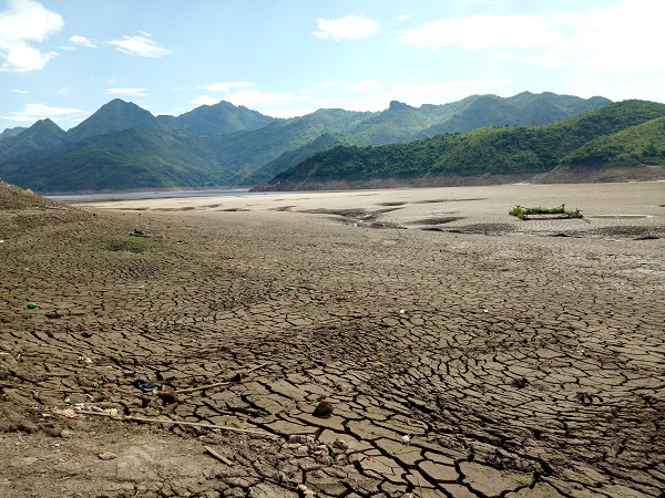
Khu vực lòng sông biến thành bãi đất rộng mệnh mông, bề mặt nứt vỡ vì nước rút cạn lâu ngày. Nơi đây tiềm ẩn rất nhiều nguy hiểm bởi trông bề mặt đất khô nhưng phía dưới là lớp bùn nhão, dễ xảy ra sụt lút, mắc kẹt khi có người di chuyển qua.
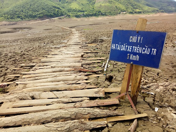
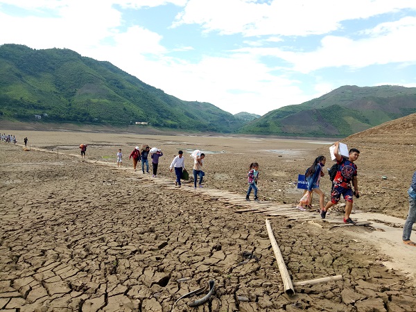
Để đi lại trên mặt bùn khu vực lòng hồ, một số người dân tại địa phương đã tự vận động nhau góp sức, góp gỗ xẻ thành từng tấm ván ghép lại, dải thành đường băng dài để di chuyển qua lại.
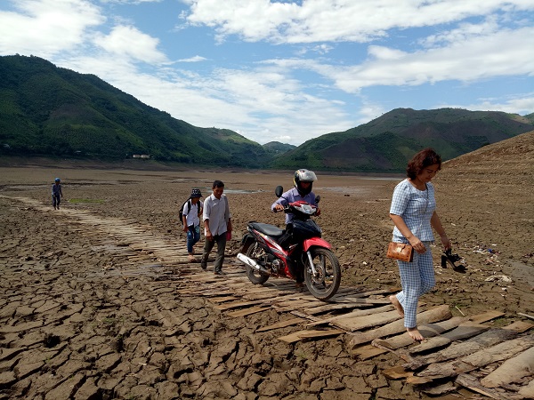
Hàng ngày, người dân phải đi lại vất vả để qua sông, người đi bộ, người dắt xe…
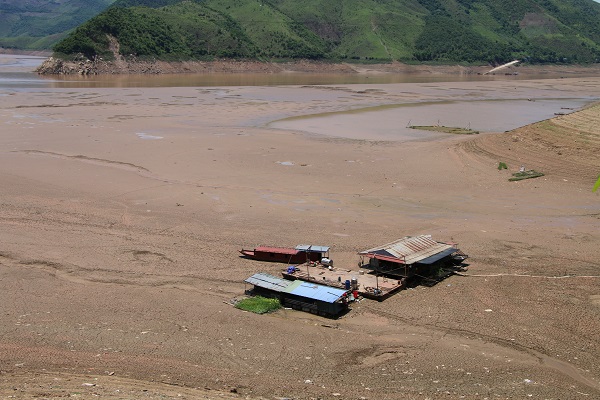
Nước rút mạnh, khu vực vùng lòng sông trơ tới đáy, nước cạn khô. Nhiều thuyền, bè, lồng nuôi cá của người dân bị mắc kẹt vì không kịp di chuyển.
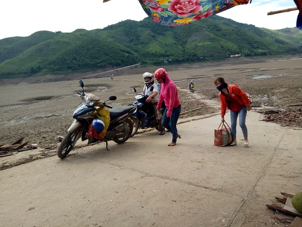
Mỗi ngày có hàng trăm lượt khách phải đi lại chật vật để mới sang được bờ sông.
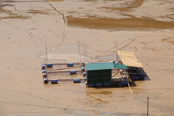
Theo người dân sống hai bên sông kể lại: Khoảng 3 – 4 năm nay, mới thấy nước sông Đà rút mạnh, hạ thấp kỷ lục như thế này. Năm nào vào khoảng tháng 5 đến tháng 9 nước sông cũng rút, nhưng mọi năm vẫn dễ ràng qua lại. Nước sông hạ thấp không chỉ gây khó khăn cho việc đi lại của người dân, mà nhiều hộ nuôi cá lồng trên vùng lòng hồ cũng bị thiệt hại nặng vì không kịp di chuyển lồng cá.
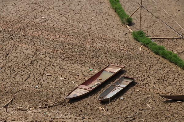
Nhiều thuyền, bè của người dân sống hai bên bờ sông phải bỏ lại nơi đất khô vì mắc cạn, sắt bị hoen gỉ, hư hỏng, biến thành đống sắt vụn.

Để qua sông người dân phải di chuyển khoảng cách rất xa đến nơi có dòng nước trũng, bởi nơi đó mới có thuyền chở đậu chở khác qua sông.
Hơn 2 tháng nay, cuộc sống của những người dân hai bên bờ sông đang bị đảo lộn, khó khăn chồng chất. Trong đó, nhiều gia đình vốn sống phụ thuộc vào nghề đánh bắt, nuôi cá, là nghề thu nhập chính, nước sông cạn khiến nhiều nông dân bị thất thu.
Nhiều cháu học sinh nhỏ phải theo chân người lớn đến trường trong cảnh khó nhọc mùa nước sông cạn.
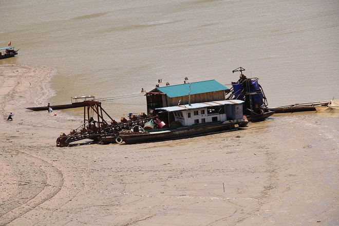
Nhiều tàu thuyền trọng tải lớn bị mắc cạn vì không thể di chuyển theo dòng nước.
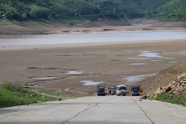
Những chiếc xe khách, xe tải chở hàng, đợi khách, đợi hàng nơi bến sông cạn.

Thượng lưu sông Đà, phía Trung quốc, có 6 đập thủy điện (và 1 đập đang dự trù):
“In China, seven dams are planned of which six, the Yayangshan Dam, Shimenkan Dam, Longma Dam, Jufudu Dam, Gelantan Dam, and Tukahe Dam, have been completed. The Xinpingzhai Dam is still in the planning stage.[3][4][5] The total installed power capacity of this series of dams is approximately 1,300 megawatts.[6]” (wikipedia)
Ở VN, sông Đà có 3 đập thủy điện lớn:
Đập Lai Châu ở huyện Mường Tè, Lai Châu, bắt đầu hoạt động 12/2016. Đập Sơn La, bắt đầu hoạt động 2012, là đâp thủy điện lớn nhất Động Nam Á. Và đập Hòa Bình ở tỉnh Hòa Bình, bắt đầu hoạt động 1994. Tổng công suất của 3 đập này là 5520 megawatts (wikipedia).
8 đập thủy điện (6 đập Trung quốc và 2 đập Lai Châu và Sơn La ở VN) nằm ở phía trên khúc sông Đà bị cạn. Có lẽ 8 đập này chặn rất nhiều nước trong mùa hạn, với El Nino đang hành. Năm nay đã được dự đoán là năm nóng nhất trong lịch sử nhân loại.
2019 could be the hottest year in human history
There is an 80 per cent chance that an El Niño will form and a 55 to 60 per cent change that the event will continue into spring of 2019, according to the Climate Prediction Center at the National Oceanic and Atmospheric Administration.
Climate scientists are closely monitoring how human-induced climate change influences El Niño, and research confirms that human-released greenhouse gases, such as carbon dioxide, have intensified El Niño events that can drive regional temperature extremes, destroy coral reefs, create droughts, and worsen wildfires.
This study projects that the current rates of climate change will prolong weather extremes and natural disasters, which will increase human deaths caused by these conditions by 50 per cent on average from now until 2100, but could increase up to 300 per cent depending on future greenhouse gas emissions.
Five of the warmest years on NASA’s record have happened since 2010, and a warmer atmosphere means stronger hurricanes, rising oceans, and longer heatwaves that burn hotter. Before the rapid atmospheric warming that has occurred since the turn of the century, a strong El Niño event from 1997 to 1998 claimed 24,000 lives globally, caused $34 billion USD in economic damages and loses, and required extensive international aid to respond to droughts, flooding, and fires in South America, Africa, and Southeast Asia. While this El Niño was exceptionally strong, this experience taught the world that each cycle can wreak havoc on the world’s weather and cause conditions that have never been seen before.
On top of the dire prediction for record-breaking heat in 2019, the interaction between climate cycles and abnormally warm temperatures indicates that future El Niño events could severely worsen climate change impacts that virtually no country on Earth is prepared to face.
Some perilous climate battles that took place just a few months ago demonstrate that the increasing weather extremes cause human health emergencies and slam economies – heatwaves claimed thousands of lives and hospitalized even more, California had it’s worst wildfire season on record as wildfires simultaneously burned in the Arctic Circle, and the combined costs of Hurricane Michael and Florence could total over $50 billion USD.
Industries have taken note of the changing environmental conditions, and significant strides have been made to develop clean energy technologies, tackle pollution, and invest in conserving the natural environment. Even though renewable energies have boomed and coal production has possibly peaked, carbon dioxide emissions from fossil fuel sources reached an all-time high in 2018. Fossil fuel sources make up approximately 90 per cent of all human-created emissions and over 37 billion tons were released, which is an increase of 2.7 per cent from 2017’s emissions output.
HOW DOES EL NIÑO FORM?
El Niño is the warm phase of the El Niño Southern Oscillation, which is the most influential climate pattern used in forecasting and can last from a number of months to three years.
This event occurs when temperatures along the equatorial region of the Pacific Ocean begin to warm and shift eastward along the equator. This movement of warm water towards the coast of South America also coincides with weakening prevailing trade winds, which sets off a feedback loop between the ocean and the atmosphere.
The energy in this feedback loop fuels jet streams and causes their paths to shift eastward and influence the track of low and high pressure systems in the Northern Hemisphere, typically resulting in temperature and precipitation changes for the months between December and February.
WATCH BELOW: NASA COMPARES THE 2015-16 EL NINO TO THE SUPER EL NINO OF 1997-98
ThíchĐã thích bởi 2 người
Em cảm ơn các thông tin của anh ạ.
Em Hương
ThíchĐã thích bởi 2 người