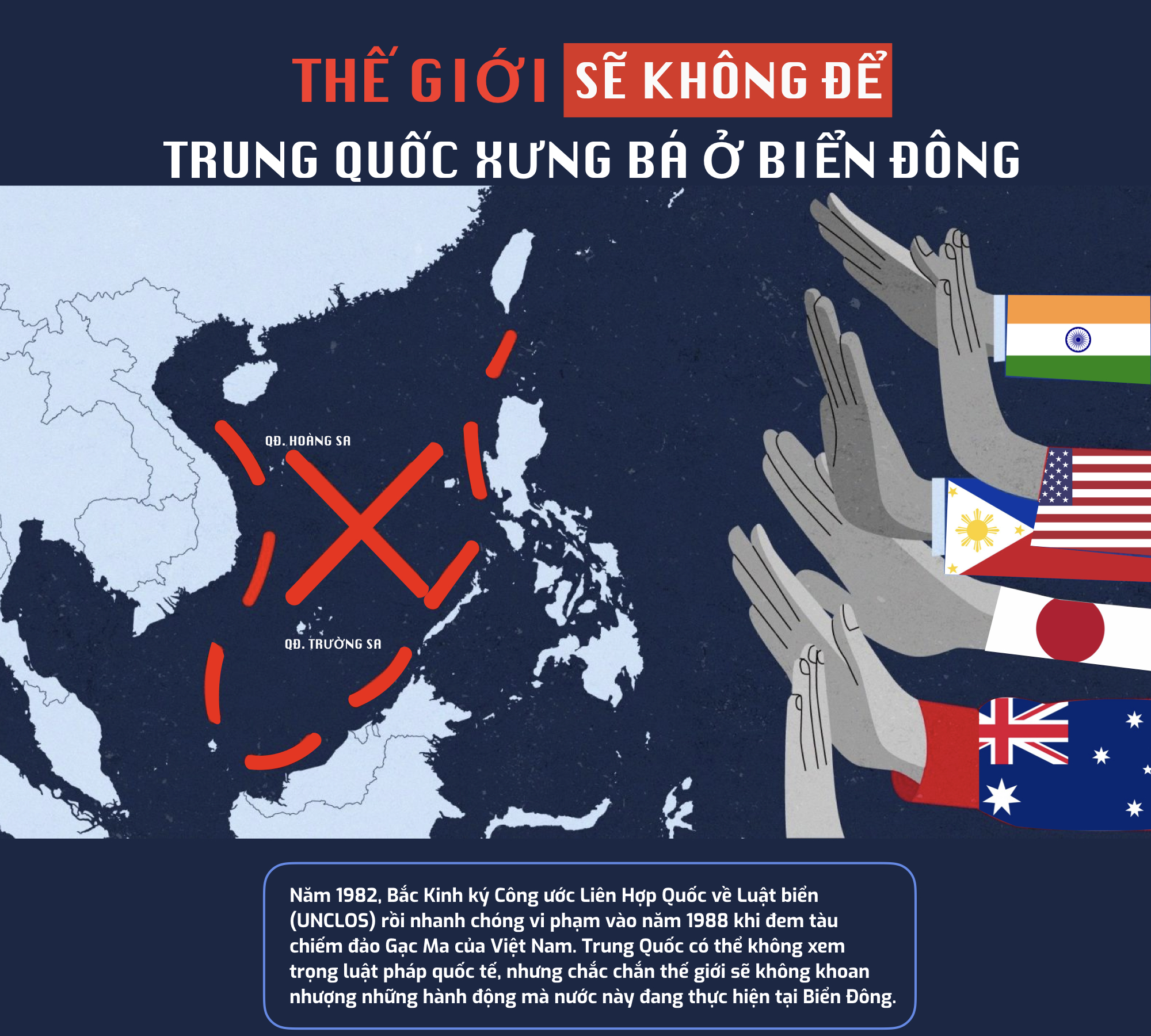
PN – Sự khao khát lãnh thổ của Bắc Kinh thể hiện rõ ràng trong lịch sử Biển Đông. Không lâu sau khi Nhật Bản bị đánh bại vào Thế chiến II, giới lãnh đạo Trung Quốc công bố bản đồ 9 đoạn vào năm 1947. Lúc ấy, dường như Trung Quốc đã nhìn thấy khoảng trống quyền lực trong vùng nước giàu có với kích thước xấp xỉ Ấn Độ và ấp ủ mưu đồ gom lấy tất cả.
Kể từ đó, Bắc Kinh sử dụng mọi cơ hội để mở rộng hoặc đánh dấu chủ quyền, bao gồm cả các trận chiến chống lại Việt Nam năm 1974 để chiếm Hoàng Sa, tiếp theo là cuộc tấn công vào đảo Gạc Ma.
Trong khi xem thường luật pháp quốc tế, Trung Quốc phải chấp nhận một sự thật rằng các quốc gia ngày càng xa rời, cô lập mình.
Giữa lúc Việt Nam đang đối mặt với đại dịch bùng phát, Trung Quốc (TQ) ngang ngược tiến hành tập trận phi pháp ở quần đảo Hoàng Sa (thuộc chủ quyền của Việt Nam). Không bất ngờ, Bắc Kinh luôn sành sỏi trong việc sử dụng sức mạnh cơ bắp để gây sức ép trước các nước ở khu vực, hòng lấn tới từng bước để biến Biển Đông thành “ao nhà”. Tuy nhiên, các động thái quấy rối và phi pháp của Bắc Kinh đang đẩy nước này lún sâu vào vòng vây cô lập của các nước.
Issues & Insights Vol. 21, SR 2 — Advancing a Rules-based Maritime Order in the Indo-Pacific
Overview
Authors of this volume participated in the Indo-Pacific Maritime Security Expert Working Group’s 2021 workshop that took place, virtually on March 23-24. The working group, composed of esteemed international security scholars and maritime experts from Japan, the United States, and other Indo-Pacific states, was formed to promote effective U.S.-Japan cooperation on maritime security issues in the region through rigorous research on various legal interpretations, national policies, and cooperative frameworks to understand what is driving regional maritime tensions and what can be done to reduce those tensions. The workshop’s goal is to help generate sound, pragmatic and actionable policy solutions for the United States, Japan, and the wider region, and to ensure that the rule of law and the spirit of cooperation prevail in maritime Indo- Pacific.
Are We Ready for the Quad? Two Contradictory Goals | Kyoko Hatakeyama, Professor of International Relations, Graduate School of International Studies and Regional Development, University of Niigata Prefecture
The Indo-Pacific Maritime Security Expert Working Group’s 2021 workshop and this volume were funded by a grant from the U.S. Embassy Tokyo, and implemented in collaboration with the Yokosuka Council on Asia Pacific Studies (YCAPS).
The statements made and views expressed are solely the responsibility of the authors and do not necessarily reflect the views of their respective organizations and affiliations. For questions, please email maritime@pacforum.org.
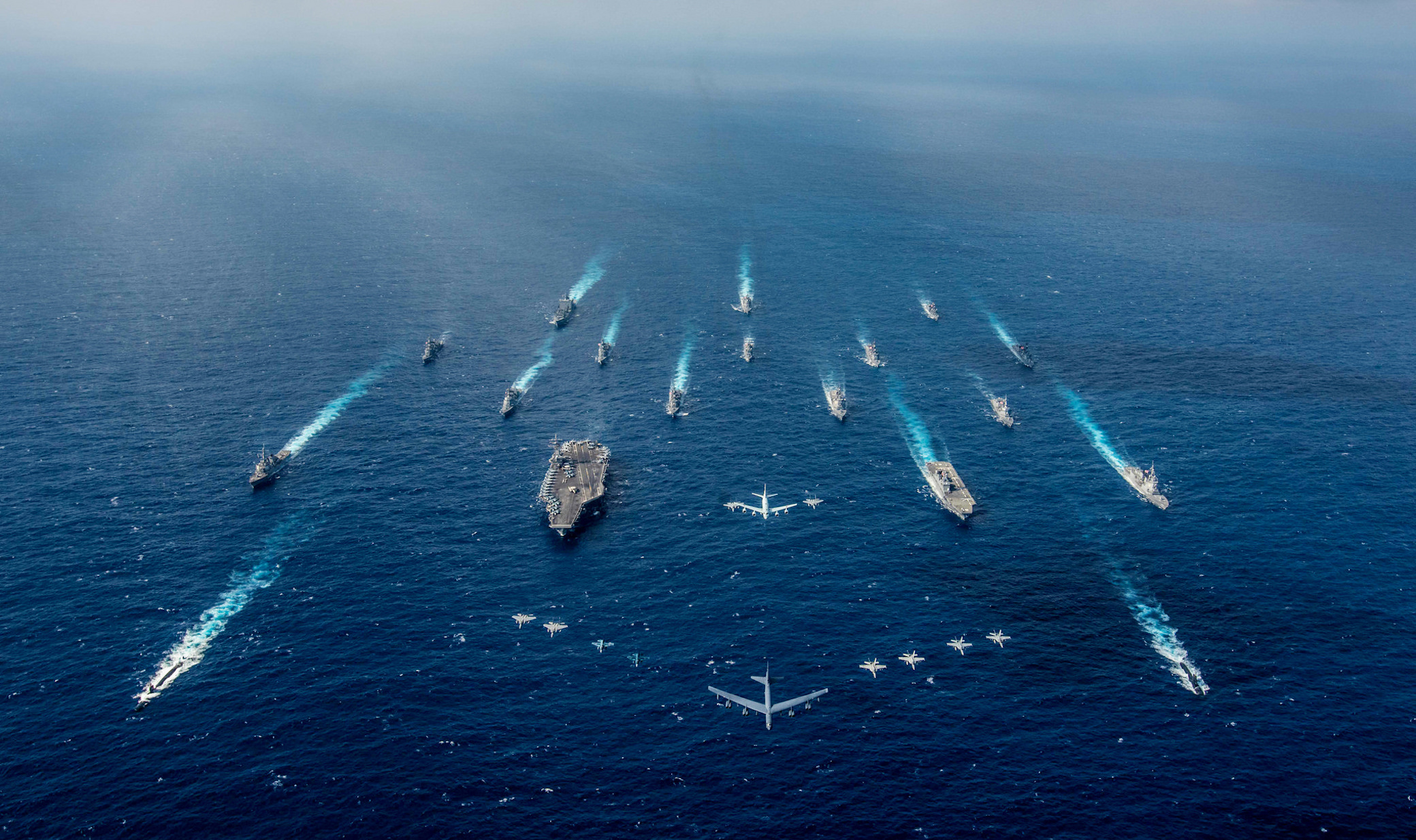
Photo: The aircraft carrier USS Ronald Reagan (CVN 76), center left, and the Japanese helicopter destroyer JS Hyuga (DDH 181), center right, sail in formation with other ships from the U.S. Navy and Japan Maritime Self-Defense Force (JMSDF) as aircraft from the U.S. Air Force and Japan Air Self-Defense Force fly overhead in formation during Keen Sword 2019 in the Philippine Sea. Keen Sword 2019 is a joint, bilateral field-training exercise involving U.S. military and JMSDF personnel, designed to increase combat readiness and interoperability of the U.S.-Japan alliance. Source: U.S. Navy photo by Mass Communication Specialist 2nd Class Kaila V. Peters/Public domain.
In this March 31, 2021, file photo provided by the National Task Force-West Philippine Sea, Chinese vessels are moored at Whitsun Reef, South China Sea. (National Task Force-West Philippine Sea via AP, File)
Joseph V. Micallef is a best-selling military history and world affairs author, and keynote speaker. Follow him on Twitter @JosephVMicallef.
At first glance, the South and East China Seas, or China Seas, and the Caribbean Sea seem to have little in common.Advertisement
Situated on opposite ends of the Earth, they are what geographers describe as enclosed seas. To a naval strategist, that’s shorthand for an environment replete with numerous choke points from which maritime traffic can be interdicted.
Beyond this geostrategic similarity, however, these seas have another common element: the parallels and contrasts with how each region has handled the emergence of new military powers.
China in East Asia
For much of its history, China has been the predominant military power in East Asia. Historically, it was the largest country, had the largest population and the largest economy. All those factors are typically prerequisites for national power — a fact as true today as it was a millennium ago. The exceptions were periods when China was internally divided, beset by weak governments unable to assert their authority, or dominated by foreign powers.Advertisement
VN Youtuber – Người được chỉ định làm Đại sứ Mỹ tiếp theo ở Việt Nam hôm 13/7 đã có phiên điều trần trước Thượng viện Mỹ và nêu ra một số ưu tiên công tác.
Tàu Trung Quốc cố tình đâm một tàu kiểm ngư của Việt Nam, trong khi một tàu khác của Trung Quốc bắn vòi rồng. Vụ việc xảy ra hồi tháng 6-2014 trên vùng biển của Việt Nam.
***
Những điểm bất hợp lý trong Luật Hải cảnh mới của Trung Quốc (kỳ 1)
08:20 12/04/2021 – cand
Sau hơn 2 tháng chính thức có hiệu lực, Luật Hải cảnh mới của Trung Quốc tiếp tục thu hút sự chú ý của dư luận và gây nhiều tranh cãi, bất bình do có những điểm vi phạm Công ước quốc tế của Liên hợp quốc về Luật Biển năm 1982 (UNCLOS 1982).
“Chúng tôi tự tin vào vụ kiện nhưng hoàn toàn hiểu rằng đây vẫn là một canh bạc”, ông Aquino nói về quyết định đưa Trung Quốc ra tòa PCA của Philippines.
Một trong những di sản của cố Tổng thống Benigno Aquino III là chiến thắng của Philippines trong phiên tòa Biển Đông. Trên thực tế, việc khởi kiện Trung Quóc không phải quyết định dễ dàng với ông Aquino, lãnh đạo một quốc gia đang phát triển và vẫn còn phụ thuộc nặng nề vào Bắc Kinh về thương mại.
Các quan chức và chuyên gia cho rằng, phán quyết của tòa trọng tài quốc tế 5 năm trước là dấu mốc quan trọng và vẫn là cơ sở hữu ích để giải quyết hòa bình các tranh chấp ở Biển Đông.
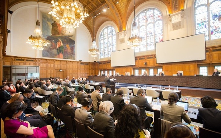
Tòa trọng tài ở La Hay tổ chức tranh tụng kín từ ngày 7-13/7/2016 cho vụ kiện của Philippines đối với Trung Quốc liên quan đến yêu sách phi pháp của Trung Quốc về Biển Đông. (Nguồn: PCA)
Phán quyết mà Tòa Trọng tài đưa ra ngày 12/7/2016 mang tính chung thẩm. Philippines kiên quyết bác bỏ các nỗ lực nhằm phá hoại phán quyết này.
Trước thềm kỷ niệm 5 năm chiến thắng mang tính bước ngoặt của Philippines trước Trung Quốc, ngày 25/6, Ngoại trưởng Philippines Teodoro Locsin Jr. tuyên bố: “Ngày kỷ niệm là một dịp để nhìn lại quá khứ, đánh dấu thành tựu của hiện tại, nhìn về tương lai và tìm cách làm việc cùng nhau vì lợi ích chung, vì không thể đạt được lợi thế nhỏ nào nếu vi phạm nó”.
The South China Sea Arbitration case decided on July 12, 2016 was an arbitration case brought against China for its effective control of maritime features in the South China Sea that are part of a territorial dispute. The case was decided in favor of the plaintiff, the Philippines, with the arbitral tribunal rejecting China’s claim of the “Nine-Dash Line,” in which China claimed historical rights over most of the South China Sea.
On the day the ruling was released, China’s Ministry of Foreign Affairs declared that “Its [the arbitration’s] existence is illegal, and whatever ruling it makes is null and void, with no binding force.” In reality, China has succeeded in turning seven artificial islands built from reefs and other features into military bases. After a U.S.-China summit in September 2015, Chinese President Xi Jinping stated that “China does not intend to pursue militarization in the South China Sea,” but in fact China has done just that. In February 2016, the Chinese Foreign Ministry explained that “China’s deployment of limited defense facilities on its own territory (the Spratly Islands) is its exercise of self-defense right to which a sovereign state is entitled under international law. It has nothing to do with militarization.” What is clear from these facts is that China is neglecting its obligation to respect the binding arbitration award. China continues its activities that go against international law.
Nhóm bạn bè của UNCLOS không phải là tổ chức có quyền ra quyết định mang tính ràng buộc pháp lý nhưng sẽ tạo diễn đàn để đại sứ đại diện các nước có thể thảo luận cởi mở vấn đề luật biển.
Nhóm bạn bè của Công ước Liên hợp quốc về luật biển (UNCLOS) năm 1982, với sự tham gia của gần 100 nước thành viên Liên hợp quốc vừa được thành lập theo sáng kiến do Việt Nam và Đức đưa ra.
Lễ ra mắt Nhóm bạn bè của UNCLOS đã được tổ chức ngày 30/6 tại trụ sở Liên hợp quốc ở New York với sự tham dự của Phó Tổng Thư ký Liên hợp quốc phụ trách các vấn đề pháp lý kiêm Cố vấn pháp lý của Liên hợp quốc Miguel de Serpa Soares và đại diện 96 nước thành viên Liên hợp quốc.
By Vu Anh June 24, 2021 | 06:30 pm GMT+7 vnexpressSatellite images by Maxar Technologies show illegally deployed Chinese military vessels and aircraft at Vietnam’s Spratly Islands, June 9, 2021. Photo courtesy of Maxar Technologies.Vietnam said Thursday that China’s deployment of ships and aircraft at Vietnam’s Spratly Islands are illegal activities holding no value.
Seas have acquired unparalleled importance in modern times owing to their trade routes and rich resource base. The territorial claims of sovereignty over the various unclaimed and disputed regions are thus on the rise fueling further conflict, friction and chances of the potential outbreak of violence. The South China Sea and its island chains are experiencing rising escalation and tension first-hand. The situation as it is in the South China Sea is very alarming owing to the power imbalance in the region. This shifted axis of power is concerning for the smaller states in South East Asia and a major threat to their territorial sovereignty.
China’s claim to the island chains is not new and has been there for a few decades now. The history of the claim can be traced to a map published at the request of the Kuomintang Govt. based on the maps drawn by some private firms and cartographic books, the Map of the South Sea Islands, issued in 1947. The 9-Dash Line used by China to claim their historical right was drawn as a part of this map to illustrate the territorial extent of China.


")


 Satellite images by Maxar Technologies show illegally deployed Chinese military vessels and aircraft at Vietnam’s Spratly Islands, June 9, 2021. Photo courtesy of Maxar Technologies.Vietnam said Thursday that China’s deployment of ships and aircraft at Vietnam’s Spratly Islands are illegal activities holding no value.
