Satellite images show significant growth in the occurrence of algal blooms in contested areas in the South China Sea.
Images suggest that these algal blooms or phytoplankton overgrowth are linked to the presence of vessels anchored in the area and to island-building activities in the region.
While satellite images help give a preview of the ecological state of the South China Sea, on-site observations are necessary to validate the findings, experts say.
Decades of territorial and maritime disputes, however, have limited the conduct of studies and dissuaded the establishment of conservation zones in the South China Sea.
Date: February 27, 2020
Source: James Cook University
Summary: New research reveals the unseen environmental damage being done to coral reefs in the hotly contested South China Sea, as China and other nations jostle for control of the disputed sea lanes.
New research reveals the unseen environmental damage being done to coral reefs in the hotly contested South China Sea, as China and other nations jostle for control of the disputed sea lanes.
Professor Eric Wolanski and Dr Severine Chokroun from James Cook University in Australia are physical oceanographers, researching the distribution, circulation, and physical properties of water.
In a new scientific paper, they argue that the disputed Spratly Islands in the South China Sea are in even more serious trouble than first believed.
“The Spratlys are the sites of a military build-up and gross overfishing, mainly by China. Reefs and islands have been destroyed to construct military outposts to further territorial claims,” said Professor Wolanski. Tiếp tục đọc “Environmental damage to coral reefs in South China Sea”→
More than half the fishing vessel in the world operate in the South China Sea, where sovereign rights have been an object of fierce contention among bordering countries.
Scientists have been warning that the sea is fast becoming the site of an environmental disaster, the impending collapse of one of the world’s most productive fisheries.
Now a group of experts that includes geopolitical strategists as well as marine biologists is calling on the disputing parties to come together to manage and protect the sea’s fish stocks and marine environment.
Effective management hinges on China’s active participation, but it remains unclear whether that country, now the dominant power in the sea with a big appetite for seafood, will cooperate.
Vox_Since 2014, China has been building islands in the middle of the South China Sea. What were once underwater reefs are now sandy islands complete with airfields, roads, buildings, and missile systems. In less than two years, China has turned seven reefs into seven military bases in the South China Sea, one of the most contentious bodies of water in the world.
href=””>United Nations Law of the Seas, which says a country’s territory extends 200 miles off its shores, an area called the exclusive economic zone, or EEZ. Any trade or resources that fall in a country’s EEZ belong to that country; they’re its sovereign territory. Any area that is not in an EEZ is considered international waters and subject to UN maritime law, meaning it’s shared by everyone. Every country in the region, which includes Malaysia, the Philippines, Brunei, and Vietnam, bases its claim to the South China Sea on the UN’s EEZ laws — except China.
China argues it has a historical claim to the South China Sea, dating back to naval expeditions in the 15th century. After World War II, the Japanese Empire lost control of the South China Sea, and China took advantage of the moment to reclaim it. On maps, it started drawing a dashed line that encompassed most of the South China Sea. This line became its official claim and is known today as the Nine-Dash Line, because it always has nine dashes. In 1973, when the UN law established EEZs, China reaffirmed its Nine-Dash Line, refusing to clarify the line’s boundaries and rejecting other countries’ claims.
Since then, tensions have built around who rightfully owns the South China Sea. The dispute has centered on the Spratly Islands, an archipelago at the heart of the South China Sea. Currently, China, Malaysia, the Philippines, and Vietnam claim some part of the Spratly Island chain. They’ve asserted their claims by putting small buildings, ports, and even some people on what are essentially rocks in the middle of the ocean.
But the Spratlys are very important, because whichever country can successfully claim themcan extend its EEZ to include them, thus gaining miles of precious sovereign territory. This is why China began building up islands in 2014. By turning these rocks into military bases, the Chinese are now able to support hundreds of ships, bolstering their presence in the region. They are using fishing boats, surveillance ships, and navy destroyers to set up blockades around other countries’ islands and defend their own. This is all done very cautiously and in small steps in order to avoid sparking a wider conflict.
Since China began building islands, the disputes have not become violent.But tensions are building in the region. As China deploys more of its military to the Spratlys, other countries are getting nervous and building up their own islands. It’s a complex situation that will continue to gain international attention, for better or for worse.
Exxon’s work is focused on a field in undisputed territory about 80 kilometers (50 miles) offshore from central Vietnam, spokesman Aaron Stryk said in response to e-mailed questions. He declined to comment on reports China warned Exxon against exploring in disputed areas.
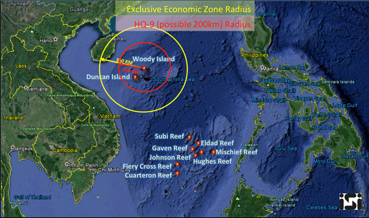
The recent deployment of missile launchers and jet fighters on Woody Island of the Paracel islands have put the spotlight on the South China Sea (SCS).
Fig 1: The 200 mile Economic Exclusion Zone claimed by China around Woody Island and the overlapping 108 nm range of the HQ-9 SAM system. Image via ISI. [Image Sat International] http://defense-update.com/20160218_woody_island_hq9.html