Climate change has threatened to erase major cities in Vietnam, including its biggest metropolis, Ho Chi Minh City. A historic downpour which sank many parts of the city late last year was seen as a mere tip of the iceberg. It’s predicted that by 2050, the city will go underwater if no concrete measures are taken to prevent the phenomenon of rising sea levels, land subsidence, weak soil foundation due to groundwater extraction, rapid developments and population growth. What has been done to respond to the gradual sinking of the city? Can it survive a looming threat to its existence?
Từ những mảnh ghép rời rạc trong quá khứ và hiện tại, liệu chúng ta có thể hiểu rõ về tình trạng lún ở Hà Nội hay không?
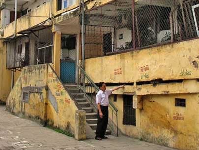
Lún ở khu tập thể năm tầng C1 Thành Công, quận Ba Đình, Hà Nội cách đây hơn 15 năm. Nguồn: Báo Tuổi trẻ
Nhưng có gì lạ với lún ở Hà Nội? Cách đây hơn 15 năm, Hà Nội đã từng chứng kiến cảnh tượng khó quên ở khu tập thể năm tầng C1 Thành Công, quận Ba Đình: mặt đất như muốn nuốt chửng hơn một nửa tầng một khiến toàn bộ tầng này chỉ còn nhô lên khỏi mặt đất chừng hơn một mét, phần cầu thang giữa hai đơn nguyên gãy gập theo đường gấp khúc, một vài cầu thang khác uốn cong theo chiều võng của tòa nhà khiến việc di chuyển được người dân sống ở đó miêu tả là “như leo thác”. Nhiều tờ báo như Tuổi trẻ, Nhân dân, CAND, Vietnamnet… vào thời điểm đó đã đồng thanh lên tiếng về hiện tượng này.
An embankment section in Tran Van Thoi District of Ca Mau Province in early August, 2020. Photo by VnExpress/Trung Dung.
With its coastal embankment threatened by collapse, Ca Mau Province is seeking urgent solutions to save residential areas and farmland.
The province entered a state of emergency Thursday to respond to any damage occurring as a three kilometer (1.86 miles) coastal embankment along its western coast nears the point of collapse due to wave impact.
Authorities have identified four sections as “especially threatened,” measuring 610 and 315 m each in U Minh District, and 1,900 m and 500 m each in Tran Van Thoi District.
“Those sections receive no forest protection. During extreme weather spells, waves would break directly against the embankment, putting it at great risk,” To Quoc Nam, deputy director of the province’s Department of Agriculture and Rural Development, said.
He confirmed the department is looking into investment projects to help counter the situation.
A sediment-poor Mekong River branch cutting through An Giang Province is causing erosion due to rapid water flow.
A three kilometer section of Hau River, a branch of the Mekong, is straitened by half in width when passing through An Giang’s Chau Phu District.
Besides this natural occurrence, the operation of upstream Mekong dams and overexploitation of sand along the river has caused erosion to eat away at nearby National Highway 91, according to experts.
In the past 10 years, erosion has thrice struck this section of Hau River, with a 500 m highway stretch pulled into the water in Binh My Commune.
Most recently, another 40 m of the highway collapsed into the river on May 27 after a crack appeared four days earlier.
In August last year, a 85-meter-long area fell into the river, followed a few weeks later by a 30 m section.
HÀ NỘI — Villages across the country have benefited from the country’s economic development, however, many do not have measures in place to deal with environmental protection.
The village of Trát Cầu in Hà Nội, which produces blankets, bed sheets and pillows, is a typical example.
Nguyễn Quang Thà, chairman of the Trát Cầu Traditional Villages Association, told Tiền Phong (Vanguard) newspaper that over the past 20 years, more and more foreign enterprises have invested in the village.
Now about 30 enterprises from Japan and South Korea are working there.
Manon Besset, Edward J. Anthony, Guillaume Brunier et Philippe Dussouillez
Giới thiệu
Đồng bằng sông Cửu Long (hình 1) được coi là đồng bằng lớn thứ ba trên thế giới với diện tích gần 100.000 km² (Coleman và Huh, 2004). Với 18 triệu dân, ĐBSCL thâm canh nông nghiệp gồm ruộng lúa, cây ăn quả cũng như nuôi tôm và cá, từng loại chiếm 60%, 70% và 60% tổng sản lượng của Việt Nam (Uỷ ban sông Mekong, 2010 ). ĐBSCL được mô tả như vựa lúa của Đông Nam Á, được nối với một con sông với chiều dài 4.750 km và lưu vực thoát nước khoảng 832.000 km² (Milliman và Ren, 1995). Lưu lượng nước trung bình ước tính của sông Mekong khoảng 14.500 m³/s (Uỷ ban Sông Mekong, 2010). Chế độ thuỷ văn hàng năm theo mùa với một mùa lũ (tháng 5 đến tháng 10), trong đó trầm tích của sông được đưa đến đồng bằng và bờ biển. Ước tính tải lượng trầm tích hàng năm của sông Mekong tại Kratie, Campuchia, chỉ ở thượng nguồn đồng bằng (hình 1), dao động từ 50 đến 160 Mt. Gió mùa Ấn Độ cũng tương ứng với sóng năng lượng thấp từ phía tây nam gây suy yếu dòng dọc bờ về phía Đông Bắc. Trong mùa này, lượng bùn cao từ sông Mekong chủ yếu lắng đọng trong khu vực gần bờ biển của các cửa sông phân lưu (Wolanski et al, 1998;.. Unverricht et al, 2013), khác với với mùa khô, lượng bùn mang tới do sóng mạnh bởi gió Đông Bắc Thái Bình Dương (hình 1). Trầm tích vận chuyển dọc theo phía tây nam từ cửa sông bởi những đợt gió tín phong, sức gió và thủy triều. Dải triều giảm từ khoảng 3m vào mùa xuân dọc theo bờ biển Nam Trung Hoa xuống dưới 1m ở Vịnh Thái Lan, cũng như vùng biển được che chắn từ các sóng theo mùa Thái Bình Dương có năng lượng cao hơn.
Vùng ĐBSCL phát triển nhanh để hình thành đường bờ dài 700 km ở Biển Đông từ 5,3 đến 3,5 ngàn năm với tốc độ bồi tụ lên đến 16 m/năm (Tạ et al., 2002). Khi tiếp xúc với sóng biển ngày càng tăng, tỷ lệ này giảm xuống dưới 10 m/năm ở cửa sông. Tuy vậy, tỷ lệ này vẫn ở mức cao lên đến 26 m/năm trong khu vực Cà Mau ở phía tây nam (Ta và cộng sự, 2002). Sự chênh lệch về tỷ lệ này là do hình thái lệch của đồng bằng về phía tây nam (hình 1). Sự khác biệt này cũng phản ánh sự biến đồi kích thước hạt, từ cát ưu thế ở cửa sông, nơi bị chi phối bởi các giồng cát (Tamura et al., 2012), đến bùn ưu thế khu vực phía tây trong quá khứ là rừng ngập mặn.
About 6.8 hectares of the Tien (Front) River will be reclaimed for the construction of a fruit park in the Mekong Delta province of Tien Giang. Photo: Tuoi Tre
A park project in Vietnam’s Mekong Delta has sparked concern among local residents for blatantly encroaching on a large area of a river, as it may cause the riverbank to collapse anytime.
For the past six months, people in Cai Lay and Cai Be Districts, Tien Giang Province, have been worried by the construction of a fruit park as it will take up a considerable portion of a local waterway.
Workers at Thủ Đức Water Company check the operation system. In addition to clean water supplied by companies like this, people in many residential areas use groundwater for their daily activities due to a shortage of tap water. — VNA/VNS Photo Ngọc Hà
Viet Nam News HCM CITY — With warnings about the ill effects of groundwater on users’ health and possible land subsidence due to overexploitation of water, 10 years ago HCM City authorities had adopted policies to reduce the use of groundwater.- Tiếp tục đọc “Groundwater use continues in HCM City”→
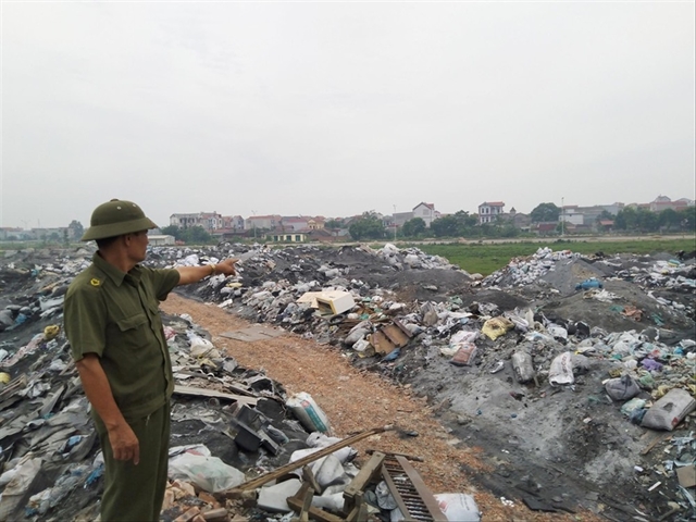
VietNamNet Bridge – The massive mineral exploitation at four sites in Dong Hy district in Thai Nguyen province has led to serious consequences: the houses of 133 families have been affected by subsidence and cracking, and locals do not have water for daily life.
Read “Key messages” and “Executive
Summary” at the end of this page
United Nations Convention to Combat Desertification
FULL REPORT
Land is an essential building block of civilization yet its contribution to our quality of life is perceived and valued in starkly different and often incompatible ways. Conflicts about land use are intensifying in many countries. The world has reached a point where we must reconcile these differences and rethink the way in which we use and manage the land.
The evidence presented in this first edition of the Global Land Outlook demonstrates that informed and responsible decision-making, along with simple changes in our everyday lives, can if widely adopted help to reverse the current worrying trends in the state of our land resources.
A third of the planet’s land is severely degraded and fertile soil is being lost at the rate of 24bn tonnes a year, according to a new United Nations-backed study that calls for a shift away from destructively intensive agriculture.
The alarming decline, which is forecast to continue as demand for food and productive land increases, will add to the risks of conflicts such as those seen in Sudan and Chad unless remedial actions are implemented, warns the institution behind the report. Tiếp tục đọc “Third of Earth’s soil is acutely degraded due to agriculture”→