I'm from Hanoi, Viet Nam.
I'm an author of Dot Chuoi Non (dotchuoinon.com/author/hangbelu/), a blog on Positive thinking, founded by Dr. Tran Dinh Hoanh, an attorney in Washington DC.
I'm a co-founder of Conversations on Vietnam Development - cvdvn.net, a virtual think tank. I am a co-founder of two companies in Viet Nam working on children education services. I advise companies on STEAM education, English language education for children and students in Vietnam.
I'm studying the Buddha's teaching and the teaching of Jesus. I practice mindful living including meditation.
I hold a PhD on Sustainable Energy Systems from University of Lisbon and Aalto University.
I graduated from Hanoi University of Technology on Environmental Engineering. I obtained a Master degree of the same major from Stanford University and Nanyang Technological University.
My English-language blog at: hangbelu.wordpress/.
I play table tennis as a hobby.
Timeline for Vietnam project too tight, Hanoi envoy says
Ties already strained over petrol motorbike ban hurting Honda
Demand surging from industry, expanding middle class
Extreme weather events also threatening supply
HANOI, Dec 8 (Reuters) – Japan has dropped out of plans to build a major nuclear power plant in Vietnam because the time frame is too tight, Japanese ambassador Naoki Ito told Reuters, potentially complicating Vietnam’s long-term strategy to avoid new power shortages.
Vietnam, home to large manufacturing operations for multinationals including Samsung and Apple, has faced major power blackouts as demand from its huge industrial sector and expanding middle class often outpaces supplies, strained by increasingly frequent extreme weather, such as droughts and typhoons.
The Reuters Power Up newsletter provides everything you need to know about the global energy industry. Sign up here.
“The Japanese side is not in a position to implement the Ninh Thuan 2 project,” the ambassador to Vietnam said, referring to a plant with a planned capacity of 2 to 3.2 gigawatts. The project is part of Vietnam’s strategy to boost power generation capacity.
Hội nghị quốc tế lần thứ V về hợp tác giữa Việt Nam và các tổ chức phi chính phủ nước ngoài
Ngày 4/12/2025, Oxfam vinh dự cùng đại diện từ hơn 300 tổ chức phi chính phủ nước ngoài (TCPCPNN) tại Việt Nam tham gia Hội nghị quốc tế lần thứ 5 về hợp tác giữa Việt Nam và các TCPCPNN, các đối tác vì sự phát triển thịnh vượng và bền vững do Ủy ban Công tác về các tổ chức phi chính phủ nước ngoài (COMINGO) và Liên hiệp các tổ chức hữu nghị Việt Nam (VUFO) tổ chức.
Hội nghị đã đánh giá kết quả quan hệ đối tác giữa Việt Nam và các TCPCPNN giai đoạn 2019 – 2025, xác định phương hướng hợp tác và nâng cao hiệu quả viện trợ trong 5 năm tiếp theo, xây dựng các kiến nghị, đề xuất với Chính phủ và Thủ tướng Chính phủ nhằm tăng cường quan hệ đối tác giữa Việt Nam với các TCPCPNN, nhà tài trợ và doanh nghiệp quốc tế trong thời gian tới.
Tính đến 30/11, có 379 tổ chức PCPNN hoạt động thường xuyên tại Việt Nam với tổng giá trị viện trợ giai đoạn 2020-2024 đạt gần 1,14 tỷ USD. Các dự án trải rộng trên phạm vi cả nước, tập trung vào những lĩnh vực thiết yếu như y tế, phát triển kinh tế – xã hội, giải quyết các vấn đề xã hội, giáo dục – đào tạo, tài nguyên – môi trường, xây dựng năng lực tổ chức và hỗ trợ tư pháp…
Phát biểu tại hội nghị, Phó Thủ tướng Bùi Thanh Sơn ghi nhận và đánh giá cao những đóng góp thiết thực, bền bỉ của các tổ chức phi chính phủ và các đối tác đối với Việt Nam trong nhiều thập kỷ qua, nhất là trong y tế, giáo dục, giảm nghèo, phát triển cộng đồng, chống biến đổi khí hậu, ứng phó với thiên tai, bảo vệ nhóm yếu thế, thúc đẩy bình đẳng giới, phát triển nông thôn.
On Oct. 13 of this year, the PRC state media outlet CPNN, reported that China is pulling ahead in advanced nuclear power technology development with the launch of the large-scale production “Hualong One” (also known as HPR1000). As it develops, China not only aims to tackle the transmission bottleneck in the south, but also to export to countries like Pakistan as the PRC’s “business card” to the world.
China’s dual goals of localization and export orientation have long defined its nuclear strategy. Led by state-owned giants such as the China National Nuclear Corporation (CNNC), Beijing has invested heavily in domestic innovation while aggressively expanding into overseas markets. Beijing has sought to expand its reactor sales to markets such as Argentina and the United Kingdom, while also securing control over upstream uranium resources. CNNC’s 2019 acquisition of Namibia’s Rössing Uranium Mine, one of the world’s largest open-pit uranium operations, underscored China’s growing dominance across the nuclear value.
Beijing’s policy support for state-owned enterprises has enabled it to build a vertically integrated nuclear industry, driving rapid advances in small modular reactors (SMRs), fourth-generation technologies, and nuclear fusion research (the Artificial Sun). Furthermore, intensifying US–China competition is reshaping global nuclear exports and deepening the geopolitical risks of dependence on Chinese nuclear systems.
Southeast Asia is facing one of its wettest seasons in recent memory, with record-breaking rain and floods — and a powerful weather combo is driving it.
In the area you have selected (Vietnam) tsunami hazard is classified as medium according to the information that is currently available. This means that there is more than a 10% chance of a potentially-damaging tsunami occurring in the next 50 years. Based on this information, the impact of tsunami should be considered in different phases of the project for any activities located near the coast. Project planning decisions, project design, and construction methods should take into account the level tsunami hazard. Further detailed information should be obtained to adequately account for the level of hazard.
Pacific “Ring of Fire” (enlarged graphic). Source: Adapted from U.S. Geological SurveyDownload Image
Climate change impact: The areas at risk of tsunami will increase as global mean sea level rises. According to the IPCC (2013), global mean sea level rise depends on a variety of factors, and estimates for 2100 range from ~20 cm to nearly 1 m. However, regional changes in sea level are difficult to predict. Projects in low-lying coastal areas such as deltas, or in island states should be designed to be robust to projected increases in global sea level.
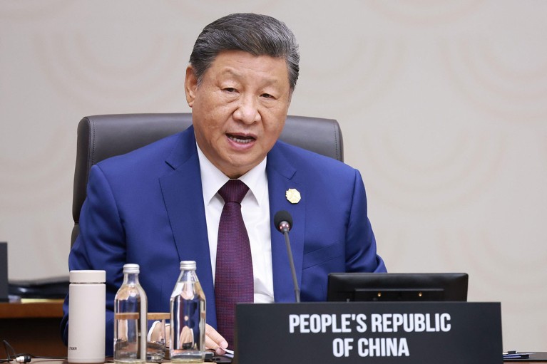
Having placed artificial intelligence at the centre of its own economic strategy, China is driving efforts to create an international system to govern the technology’s use.
Chinese president Xi Jinping speaking at the 2025 Asia-Pacific Economic Cooperation meeting in Gyeongju, South Korea.Credit: Yonhap via AP/Alamy
Thousands of people march in the sidelines of the COP30 UN Climate Change Conference in Belém, Brazil on Nov. 15, 2025.Pablo Porciuncula—AFP via Getty Image
by Brian Mukhaya Brian Mukhaya is the Africa Program Manager at Clean Air Task Force.
Ten years after the landmark Paris Agreement, the world is still trying to solve two crises as if they were separate: climate change and economic development. That’s a dangerous illusion. Climate progress cannot succeed if billions of people remain in poverty, without electricity, stable food systems, or the means to build better lives. And development, if it ignores climate risk, is little more than a short-term fix that will collapse under the weight of future disasters.
I saw this tension firsthand at COP30 in Belém, Brazil, the annual UN climate summit. The energy there was unmistakable—a mixture of urgency and frustration. Delegates from across Africa reminded the world that promises made in Paris have not been kept. Wealthy nations pledged to support developing countries as they cut emissions and adapted to rising temperatures. Yet, a decade later, those commitments remain largely unfulfilled.
At COP29 in Baku last year, developed countries agreed to mobilize at least $300 billion annually by 2035 for developing countries’ climate action, part of a broader aspirational target of $1.3 trillion per year. While this represents a tripling of the previous $100 billion goal, representatives from developing countries remain skeptical. More fundamentally, the $300 billion commitment falls far short of actual needs. The Independent High-Level Expert Group on Climate Finance estimates that developing countries (excluding China) need approximately $2.7 trillion annually by 2030 to meet climate and nature-related goals. The gap between promise and reality remains vast—and widening
But money is only part of the problem. Even when funding arrives, it often misses the mark. A new analysis by the Clean Air Task Force looked at 52 African countries’ climate and development plans. It found that the two rarely intersect. Climate strategies focus on emissions and energy transitions, while national development plans emphasize job creation and economic growth—but without embedding climate targets. The result is a patchwork of policies that fail to deliver either lasting prosperity or real emissions cuts.
As Bill Gates noted in a recent memo, global climate policy increasingly risks sidelining development altogether. Today, more than 600 million Africans lack access to electricity, while 900 million do not have clean cooking technologies—conditions that undermine productivity, constrain public services, and contribute to preventable deaths.
Crucially, this should not be understood as an either/or dilemma. Wealthy nations already recognize that decarbonization must go hand in hand with economic growth to be politically viable at home. The same is true globally. Emerging and developing economies cannot be expected to choose between climate progress and economic progress. Insisting on a tradeoff between the two as a trade-off is both unrealistic and unjust.
When climate and development are treated as separate silos, everyone loses. Fragmented planning leads to inefficient allocation of scarce resources, missed opportunities for infrastructure investments with broad benefits, and policies that fail to produce either meaningful emissions reductions or durable socio-economic progress. Importantly, this is not a challenge restricted to Africa but a blind spot in international climate governance. Even wealthy countries are discovering that climate action divorced from economic realities is politically unsustainable. When climate action appears to threaten economic growth, job creation, or living standards, political support erodes quickly.
As negotiations in Belém draw to a close, one truth should be clear: climate and development are not competing agendas—they are the same story. Sustainable development is the foundation of lasting climate progress. And climate resilience is the only path to enduring prosperity. Any strategy that treats them separately is doomed to fail.
Development without climate action is a short-term fix. And climate action without development is an empty promise.
GN – Xuất gia báo hiếu là một nét đẹp truyền thống lâu đời của người Khmer Nam Bộ. Lễ nhập tu báo hiếu này thường được tổ chức vào khoảng thời gian trước hoặc sau Tết Chôl Chnăm Thmây.
Theo phong tục của người Khmer Nam Bộ, nam thanh niên 16 tuổi trở lên thường vào chùa xuất gia tu học từ một đến vài năm. Tuy nhiên, chuyện vào chùa tu là điều không bắt buộc, họ có thể tu vào lúc nào đó thích hợp và muốn tu một hay nhiều năm đều được.
Theo HT.Danh Lung, việc đi tu báo hiếu cho ông bà, cha mẹ là một nét đẹp trong cộng đồng Phật tử trẻ Khmer; bên cạnh đó, một điều không kém phần quan trọng, là chỉ những thanh niên từng tu tập ở chùa mới dễ có cơ hội… lấy vợ. Các cô gái và gia đình họ chỉ ưng những chàng trai đã từng trải nghiệm đời sống xuất gia.
, Hironori Kato baDepartment of Architecture and Civil Engineering, City University of Hong Kong, Tat Chee Avenue, Kowloon, Hong KongbDepartment of Civil Engineering, The University of Tokyo, 7-3-1, Hongo, Bunkyo-ku, Tokyo, 113-8656 Japan
Highlights • We examine the relationship between airport rail links and metropolitan productivity. • Cities with airport rail links are more productive than those without airport rail links. • Cities with shorter access time enabled by airport rail links are more productive. • Airport rail links should be discussed as a catalyst for wider economic development.
Thông Tấn Xã VN Baotintuc.vn Thứ Ba, 11/06/2013 21:15 |
Nghi Xuân – mảnh đất địa linh nhân kiệt, từ xa xưa đã sản sinh ra bao nhân tài cho đất nước, được ví là “cái nôi” văn hóa của quê hương Hà Tĩnh. Trên mảnh đất này, nhiều loại hình văn nghệ dân gian xuất phát từ lao động, sinh hoạt của nhân dân như: ca Trù, trò Kiều (có nơi gọi là chèo Kiều), hò Nghẹt… nhưng tiêu biểu nhất là trò Kiều vì nó đã đi vào lòng người và được nhân dân mến mộ từ bao đời nay.
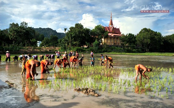
Một cảnh diễn trò Kiều.
Theo ông Nguyễn Ban, hậu duệ chi ất đời thứ VI của Đại thi hào Nguyễn Du, nguyên trưởng phòng Văn hóa thông tin (cũ) huyện Nghi Xuân, người đã tốn nhiều công sức để khôi phục lại trò Kiều: Sau khi có Truyện Kiều, khoảng nửa thế kỷ sau, các loại hình văn nghệ dân gian dựa trên Truyện Kiều bắt đầu xuất hiện. Khoảng cuối thế kỷ XIX, ở vùng Bắc Nghệ An, Truyện Kiều được chuyển thể sang trò Kiều – sự kết hợp giữa hát tuồng và hát chèo Kiều kết hợp với diễn xuất, làm trò và các làn điệu khác như: dân ca, ví Dặm Nghệ Tĩnh, ca Huế, ca Trù…
So, where does this hidden labor take place? According to Casilli’s research, workers are in countries including Kenya, India, the Philippines, and Madagascar — regions with high levels of digital literacy, access to English- or French-speaking workers, and little in the way of labor protection or union representation.
Behind most of today’s AI models lies the labor of workers in the Global South, who are exposed to disturbing content and poor working conditions. This reality raises urgent questions about the transparency and ethics of AI development.
Picture working 10-hour days tagging distressing images to train an AI model — and getting paid not in money, but in a kilogram of sugar. This isn’t dystopian fiction, but reality for some of the workers behind today’s most advanced artificial intelligence.
While the development of AI is undoubtedly enhancing the lives of many by streamlining processes and offering efficient solutions, it also raises a pressing question: What is the true cost of AI, and who is paying for it?
Antonio Casilli, Professor of Sociology at Télécom Paris and Founder of DipLab, addressed this question during an Esade seminar on the promises and perils of the digitalization of work. The event was part of the kick-off for the DigitalWORK research project, which explores how digital technologies are transforming work and promoting fair, equitable and transparent labor conditions, with Anna Ginès i Fabrellas and Raquel Serrano Olivares (Universitat de Barcelona) as principal investigators.
Ngay sau bão số 15, cơn bão Senyar được đánh giá là cơn bão có một không hai trong lịch sử hơn 180 năm qua.
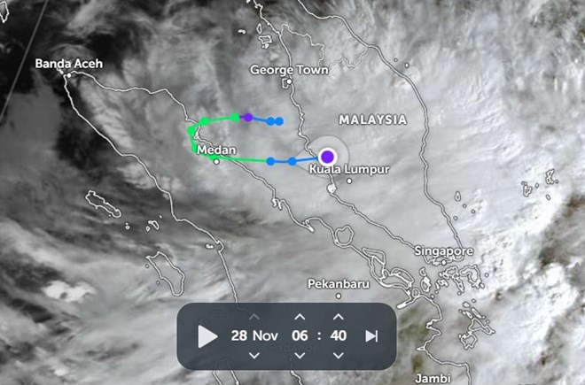
Sau bão số 15, xuất hiện bão Senya. Trong ảnh là đường đi của bão lúc 6h40 ngày 28.11. Ảnh: Zoom Earth
Bão Senyar – hiện tượng khí tượng được đánh giá là “chưa từng có tiền lệ” trên eo biển Malacca – không chỉ lập hàng loạt kỷ lục hiếm gặp mà còn để lại một vùng áp thấp có khả năng tác động trực tiếp đến Biển Đông trong vài ngày tới.
Dưới ảnh hưởng của bão số 15, vùng áp thấp này có thể bị hút ngược ra Biển Đông và mạnh lên trở lại thành áp thấp nhiệt đới vào khoảng ngày 29.11.
Nếu hình thành xoáy thuận mới, đây sẽ là xoáy thuận nhiệt đới thứ 21 trên Biển Đông năm 2025, vượt kỷ lục 20 cơn của năm 2017, qua đó lập kỷ lục lịch sử về số xoáy thuận hoạt động trong 1 năm.
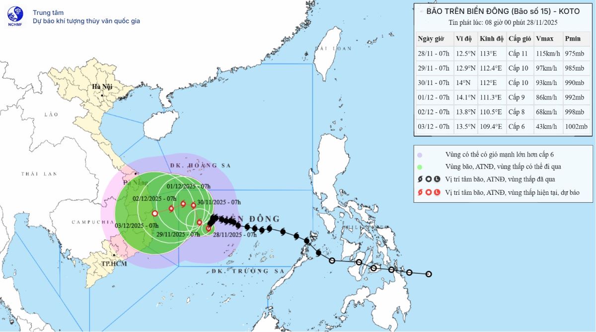
Vị trí và dự báo hướng đi của bão số 15 lúc 8h sáng 28.11. Ảnh: Trung tâm Dự báo khí tượng thủy văn quốc gia Việt Nam
Senyar: Cơn bão “có một không hai” trong lịch sử khí tượng
Bão Senyar tan sau khi đổ bộ vào bờ Tây Malaysia rạng sáng 28.11, nhưng ngay lập tức được ghi nhận là một trong những hiện tượng khí quyển đặc biệt nhất khu vực Ấn Độ Dương – Tây Bắc Thái Bình Dương.
Theo tin bão của Cục Khí tượng Malaysia (MetMalaysia), bão đổ bộ khoảng 1h sáng 28.11 vào giữa Banting và Port Dickson, sau đó suy yếu khi đi vào Pahang, nhưng vẫn gây mưa từng đợt tại nhiều bang do hoàn lưu thấp còn sót lại.
Lý do Senyar gây chấn động giới khí tượng nằm ở hàng loạt kỷ lục mới được xác lập:
Cơn bão nhiệt đới đầu tiên trong lịch sử hơn 180 năm qua hình thành ngay trên eo biển Malacca, khu vực vốn được xem là không có bão. Kể từ năm 1842, chưa từng có xoáy thuận nhiệt đới mạnh nào được ghi nhận tại vị trí Senyar xuất hiện.
Cơn bão đầu tiên được Cục Khí tượng Ấn Độ (IMD) đặt tên tại vị trí này.
Cơn bão có vĩ độ hình thành thấp thứ hai kể từ khi IMD đặt tên bão năm 2004.
Cơn bão đầu tiên đổ bộ Sumatra (Indonesia) trong tháng 11 trong hơn 1 thế kỷ dữ liệu.
Cơn bão có sức gió mạnh nhất khi đổ bộ Sumatra, vượt qua bão Vamei (2001).
Cơn bão có tên đầu tiên đổ bộ Indonesia trong lưu vực Bắc Ấn Độ Dương.
Cơn bão thứ hai trong lịch sử đổ bộ phần lãnh thổ Indonesia thuộc Bắc Bán Cầu.
Cơn bão đầu tiên đổ bộ Indonesia trong tháng 11 kể từ bão 03S (2001).
MetMalaysia nhấn mạnh rằng Malaysia vốn nằm ngoài đường đi của bão nhiệt đới, do đó sự xuất hiện của Senyar là “cực kỳ bất thường”. Cơ quan này tiếp tục phát cảnh báo mưa lớn đến hết ngày 29.11 và theo dõi sát diễn biến của hoàn lưu còn lại.
Vùng áp thấp sau Senyar: Nguy cơ tái sinh thành xoáy thuận trên Biển Đông
Điều đáng lo ngại hơn nằm ở vùng áp thấp hình thành sau khi bão Senyar tan. Vùng xoáy yếu này đang tồn tại phía Tây Malaysia và hiện di chuyển chậm.
Dưới tác động của cơn bão số 15 (lúc 7h sáng 28.11 ở vào khoảng 12,5 độ vĩ bắc, 113,0 độ kinh đông, cách đảo Song Tử Tây khoảng 190km về phía tây bắc), vùng áp thấp có thể bị hút sang phía đông, một hiện tượng lần đầu tiên được ghi nhận giữa hai lưu vực khí hậu Ấn Độ Dương và Tây Bắc Thái Bình Dương.
Các mô hình dự báo bão cho thấy, khi tiến ra Biển Đông, vùng áp thấp này có thể mạnh lên thành áp thấp nhiệt đới trong khoảng ngày 29.11. Nếu điều này xảy ra, đây sẽ là cơn áp thấp hoặc bão thứ 21 hoạt động ở Biển Đông năm nay – con số chưa từng có.
Satellite images show how data centers are changing America’s landscape
Business insider
Data centers across the street from residential housing are not an uncommon scene in Virginia.
There are over a thousand planned or existing data centers across the US, according to a BI investigation.
Major tech companies are racing to construct even more as the AI boom continues. But at what cost?
Satellite images show where these facilities are cropping up and why they’re a nuisance to many.
Build, baby, build. That’s the mantra behind the AI boom sweeping America.
This year, alone, Amazon, Meta, Microsoft, and Google are projected to spend about $320 billion in capex, mostly for AI infrastructure, according to an analysis of financial statements by Business Insider.
At the heart of this AI infrastructure growth are data centers that house the specialized hardware and high-speed networking equipment, driving the intensive computations behind large language models. However, AI needs more.
Because AI learns by processing increasingly large amounts of data, improving it requires more computational power, which in turn necessitates more data centers.
A BI investigation found 1,240 data centers across America are already built or approved for construction by the end of 2024.
Giữa nhiều mặt hàng cứu trợ quen thuộc, có một số vật phẩm gần đây được nhắc đến nhiều hơn – băng vệ sinh và đồ lót sạch. Đây là tín hiệu đáng mừng vì những sản phẩm vệ sinh và kinh nguyệt – vốn rất thiết yếu với phụ nữ và trẻ em gái – đã được nhìn nhận đúng vai trò của chúng trong các gói cứu trợ khẩn cấp.
Tuy nhiên, đâu đó vẫn có người hoài nghi về tầm quan trọng của băng vệ sinh và đồ lót sạch: “Đồ cá nhân sao lại đưa vào danh sách?”, “Người ta cần ăn, cần uống, đâu cần băng vệ sinh?”… Những phản ứng ấy cho thấy vẫn tồn tại khoảng cách trong nhận thức về kinh nguyệt, đặc biệt là trong cứu trợ thiên tai – khi những nhu cầu cơ bản nhất lại trở nên khó tiếp cận hơn bao giờ hết.
BĂNG VỆ SINH, ĐỒ LÓT SẠCH LÀ NHU CẦU THIẾT YẾU
Trong bối cảnh biến đổi khí hậu, thiên tai đang trở nên bất thường, dữ dội và khó dự đoán với nhiều quốc gia, trong đó có Việt Nam. Khi thiên tai xảy ra, hàng nghìn, thậm chí là chục nghìn hộ dân phải sơ tán hoặc rơi vào cảnh thiếu thốn trầm trọng: mất điện, thiếu nước sạch, khan hiếm thực phẩm, nhà cửa hư hại, đường sá bị chia cắt khiến nhiều nơi bị cô lập.


. Source: Adapted from U.S. Geological Survey")


.JPG)