As the name suggests, liquefied natural gas (LNG) involves turning gas into liquid form — a process known as liquefaction. Liquefaction does not alter the chemical makeup of gas, which is comprised of mostly methane plus varying amounts of different impurities, but it does make it denser. This enables ships and other carriers to move more gas over oceans between locations that lack direct pipeline connectivity.
(TN) Trong năm 2025, Báo Thanh Niên đã xuất bản hàng trăm ngàn bức ảnh, ghi lại các sự kiện thời sự quan trọng của đất nước, những khoảnh khắc báo chí, cùng hàng ngàn nhân vật và câu chuyện đời sống xã hội trên khắp mọi miền Tổ quốc. Những khung hình với mong muốn phác họa bức tranh toàn cảnh về Việt Nam năm 2025 trong giai đoạn chuyển mình mạnh mẽ sau cuộc cách mạng sắp xếp lại đơn vị hành chính.
Trong bối cảnh thế giới đang nỗ lực giảm phát thải khí nhà kính và chuyển dịch sang nền kinh tế carbon thấp, khí thiên nhiên hóa lỏng (LNG) thường được nhắc đến như một “nhiên liệu chuyển tiếp sạch”, thay thế cho than đá và dầu mỏ trong sản xuất điện. Tuy nhiên, mức độ “sạch” của LNG vẫn là một câu hỏi gây tranh cãi, không chỉ vì những con số phát thải CO₂ thấp hơn khi đốt, mà còn bởi các tác động khí hậu tiềm ẩn từ toàn bộ chuỗi cung ứng – đặc biệt là rò rỉ khí metan. Bài viết này sẽ phân tích toàn diện các khía cạnh phát thải của LNG so với các nhiên liệu hóa thạch khác, dựa trên đánh giá vòng đời khí thải (LCA), nhằm đưa ra góc nhìn cân bằng và thận trọng về vai trò thực sự của LNG trong quá trình chuyển đổi năng lượng.
1. Phát thải khí nhà kính: LNG so với than đá và dầu mỏ
Các nhà máy điện tuabin khí sử dụng LNG thải ra khí nhà kính (chủ yếu là CO₂) ít hơn đáng kể so với các nhà máy điện than và dầu, nếu xét trên mỗi kWh điện sản xuất. Theo ước tính trung bình của IPCC, một nhà máy điện chạy khí thiên nhiên phát thải khoảng 490 g CO₂ tương đương mỗi kWh, trong khi con số này với than đá khoảng 820 g CO₂e/kWh và dầu nhiên liệu khoảng 600 g CO₂e/kWh. Sự khác biệt này chủ yếu do khí tự nhiên có tỷ lệ hydro/carbon cao hơn, cho hiệu suất đốt cao và sinh ít CO₂ hơn so với than và dầu cho cùng một lượng nhiệt năng.
In the early 2010s, the coal industry attracted a large wave of investment, banking on surging coal imports from China and India.
When this growth didn’t materialise, coal oversupply and depressed prices sent major companies bankrupt with significant value destruction for shareholders.
The LNG industry risks repeating the coal industry’s mistakes, as investment levels outstrip future demand, with potentially more severe consequences for the capital-intensive industry.
Peddling a ‘supercycle’ for coal in the 2010s
In the early 2010s, the coal industry was on the rise. Global trade had tripled between 1990 and 2011, with the 2000s experiencing “the largest growth in coal demand in history – greater than the previous four decades combined”. This growth was expected to accelerate after China and India entered the global coal import market (Figure 1). Between 2011 and 2012, global coal imports increased by 13% and coal prices doubled (Figure 2).
Tiasang – COP30 đã thay đổi cách đánh giá và phân bổ tài chính cho thích ứng với biến đổi khí hậu. Từ nay, dòng tài trợ chỉ đến quốc gia nào chứng minh được rủi ro, đo được hiệu quả sử dụng tiền tài trợ và quản trị minh bạch. Vốn rất cần nguồn tài trợ quốc tế để chống chịu và phục hồi, Việt Nam sẽ phải điều chỉnh cách tiếp cận nguồn tài chính quốc tế như thế nào?
Satellite analysis has identified 517 suspected riverbank mines in Laos, many likely illegal, with clusters along key Mekong tributaries, raising fears of widespread, unmonitored contamination.
Officials in Attapeu province confirmed illegal mining remains pervasive despite crackdowns, with most operations missing from official records and many linked to Vietnamese or Chinese supply chains.
The mining surge, including gold and rare earth extraction, poses major risks to ecosystems and communities in the Mekong Basin, where water testing capacity is weak and signs of declining fish populations and polluted rivers are emerging.
Researchers say Mekong countries must coordinate regionally and engage China, the main importer of the region’s mining output, while strengthening enforcement and environmental oversight to address a rapidly expanding, largely unregulated mining sector.
Chủ tịch Hội thủy lợi Việt Nam cho biết trước đây khi ngành thủy lợi làm quy hoạch cho các lưu vực ở miền Trung, sông nào cũng có dung tích phòng lũ. Song khi thay đổi đầu mối quản lý, với việc xây dựng ồ ạt nhiều dự án thủy điện, các bộ ngành phối hợp không chặt chẽ, nên dung tích phòng lũ ở miền Trung gần như không có hoặc không đáng kể.
Nhật ký lũ trên cột nhà ông Nguyễn Văn Biên (82 tuổi) ở Hội An, Đà Nẵng, năm nay khắc thêm một dấu mốc mới – 2025, vượt tất cả năm lịch sử ông từng ghi dấu trước đó – 1964, 1999, 2007, và 2009.
Trận lũ Giáp Thìn diễn ra 61 năm trước vẫn là nỗi ám ảnh với ông Biên. Nước lũ ngập quá căn nhà cổ một tầng. Chàng thanh niên 20 tuổi cùng cha mẹ vác theo 3 kg gạo, gói vài bộ áo quần, bơi qua trú tạm ở căn nhà hai tầng đối diện. Họ thất thần nhìn dòng nước lũ nhấc bổng những căn nhà tranh, và cuốn trôi không ít phận người xấu số.
“Không có ngôi nhà hai tầng đó, chắc mình cũng giống họ”, ông nhớ lại.
Không ai thống kê số người tử nạn năm đó. Nhưng ông Biên chắc chắn nó gây thiệt hại hơn cả trận “đại hồng thuỷ” năm 1999, khiến 595 người chết và mất tích tại 10 tỉnh, thành, trong đó Quảng Nam (cũ) và Đà Nẵng là 110 người.
Ký ức từ những trận lũ lịch sử trở thành bài học cho nhiều thế hệ sống nơi tâm lũ như ông Biên. Khi tích lũy đủ tiền để sửa nhà năm 2018, ông ngẫm ngập phố cổ chưa năm nào quá 3 m, nên quyết định nâng sàn tầng hai cao hơn mặt đường 4 m, và cách mặt sông Hoài chừng 5 m. Đêm 30/10, nước lũ lên nhanh, ngập đến 2,5 m cột nhà, vượt cả mốc lũ năm 1964. Lúc ấy, ông lo sợ lịch sử lặp lại, phải tính đến phương án xấu nhất sẽ gọi cứu hộ thế nào.
May mắn, nước chưa lên tới tầng hai, nhưng ngập đến ngày thứ 5 mới rút, ít ngày sau lại lên lại. Trong hơn 10 ngày từ 22/10 đến 3/11, người dân Hội An chạy lũ ba lần. Toàn thành phố Đà Nẵng (sau sáp nhập) ghi nhận 15 người chết và 3 mất tích, thấp hơn nhiều con số năm 1999.
The world is facing an unprecedented housing crisis. According to the latest UN-Habitat estimates, 318 million people are homeless, while 2.8 billion people—over a third of the global population—lack access to adequate housing. Behind these stark figures lie deep inequalities that undermine social progress and human dignity.
Adequate housing is more than shelter, it is a foundation for stability, health, education, and opportunity. Without a safe and secure home, individuals are more vulnerable to poverty, exclusion, and poor health outcomes. Homelessness also carries a heavy social cost, eroding trust, cohesion, and the potential for societies to thrive.
The housing challenge is global but manifests differently across contexts. In rapidly urbanizing regions, millions live in informal settlements or slums, where basic services are scarce and conditions unsafe. Today, 1.1 billion people live in such informal settlements, with 90 percent concentrated in Africa and Asia. Conflict, economic inequality, climate change, and natural disasters are major drivers of displacement and housing insecurity, pushing millions into precarious living conditions.
The urgency of the crisis was underlined at the UN-Habitat Assembly in Nairobi (29–30 May 2025), where Member States adopted the UN-Habitat Strategic Plan for 2026–2029. The plan places affordable housing, secure land tenure, and access to basic services at the heart of global priorities. Leaders called for bold and coordinated action, stressing that housing must be treated as a human right and a cornerstone of sustainable development.
The right to adequate housing is embedded in international human rights instruments and explicitly tied to the 2030 Agenda for Sustainable Development. Goal 11 commits the international community to make cities and human settlements inclusive, safe, resilient, and sustainable. Addressing homelessness and housing insecurity is therefore essential to achieving the SDGs and ensuring that no one is left behind.
Tackling homelessness and inadequate housing requires integrated strategies at local, national, and global levels:
Scaling up affordable housing initiatives through innovative financing, public-private partnerships, and policy reforms.
Expanding social protection systems to prevent families from falling into homelessness.
Investing in resilient housing solutions to adapt to the realities of climate change and disasters.
Strengthening community-based models such as cooperatives and housing associations that empower people to participate in shaping their own futures.
Homelessness is not inevitable. With coordinated action and commitment, the global community can reverse these trends. As the world prepares for the Second World Summit for Social Development in Doha, 4-6 November 2025, the message is clear: accelerating social progress requires that every person has access to a safe, secure, and dignified place to call home.
PGS. Trương Quang Thông– Đại học Kinh tế TPHCM (UEH)
Kinh nghiệm quốc tế cho thấy Việt Nam là ngoại lệ trong khu vực. Ở Trung Quốc, người mua căn hộ thứ hai phải đặt cọc tối thiểu 60-70% và trả lãi suất cao hơn 30% so với căn đầu tiên. Còn Hàn Quốc thì cấm hoàn toàn vay thế chấp để mua nhà thứ hai ở các “khu đầu cơ” (speculative zones). Đảo quốc Singapore áp dụng quy định “Loan-to-Value ratio” rất chặt chẽ, giới hạn 45% cho căn thứ hai và 35% cho căn thứ ba (Monetary Authority of Singapore, 2023).
(KTSG) – Giá nhà không chỉ phản ánh cung – cầu vật chất, mà còn là tấm gương phản chiếu của chính sách phân phối cơ hội. Khi tín dụng và thuế đều ưu ái người đã có tài sản, hệ thống trở nên bất công, và bất động sản trở thành nơi tích tụ rủi ro tài chính lẫn khủng hoảng niềm tin.
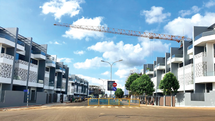
Nhà đất vẫn trở thành biểu tượng của thành công và nơi trú ẩn an toàn cho vốn tư nhân. Ảnh: N.K
Trong ba thập niên qua, Việt Nam đã chứng kiến những đợt tăng giá bất động sản mạnh nhất khu vực Đông Nam Á. Giá căn hộ tại trung tâm TPHCM và Hà Nội cao gấp 20-30 lần thu nhập bình quân năm của một người lao động có kỹ năng trung bình (World Bank, 2023). Mức chênh lệch này cao gấp 3 lần so với Thái Lan và gần gấp 4 lần so với Hàn Quốc trong những giai đoạn so sánh tương tự.
Việt Nam đang đẩy mạnh triển khai các cam kết quốc tế về giảm phát thải khí nhà kính theo Công ước khung của Liên Hợp Quốc về Biến đổi khí hậu và Thỏa thuận Paris, với mục tiêu đạt phát thải ròng bằng “0” vào năm 2050 do Thủ tướng Chính phủ công bố tại COP26. Trong chiến lược đó, rừng được xác định là một trong những trụ cột quan trọng nhất nhờ vào khả năng hấp thụ và lưu giữ các-bon tự nhiên, đồng thời có tiềm năng hình thành thị trường các-bon rừng – một cơ chế tài chính mới nhằm thúc đẩy bảo vệ và phát triển rừng theo hướng bền vững.
Hiện nay, Cục Lâm nghiệp và Kiểm lâm đang chủ trì xây dựng Nghị định về các-bon rừng và Bộ tiêu chuẩn các-bon rừng quốc gia, nhằm tạo nền tảng pháp lý thống nhất cho đo đạc, thẩm tra, chứng nhận và giao dịch tín chỉ các-bon từ rừng. Mặc dù sau hơn ba thập kỷ bảo vệ và phát triển rừng, Việt Nam đã đạt được nhiều kết quả đáng kể, hệ thống pháp luật hiện hành vẫn thiếu các quy định cụ thể về quyền các-bon rừng — bao gồm quyền sở hữu, quyền giao dịch, quyền định đoạt và quyền hưởng lợi từ kết quả giảm phát thải. Những khoảng trống này đặt ra nhiều câu hỏi cho các nhà hoạch định chính sách và các chủ rừng, đặc biệt trong giai đoạn chuẩn bị vận hành thị trường các-bon.
Trong bối cảnh đó, Mạng lưới Nghiên cứu Chính sách tổ chức webinar “Thực trạng quản lý và sử dụng rừng ở Việt Nam – Ý nghĩa đối với các quyền và thị trường các-bon rừng trong tương lai” nhằm phân tích và thảo luận các vấn đề nêu trên.
Webinar tập trung vào các nội dung:
Phân tích thực trạng quản lý và sử dụng rừng tại Việt Nam, bao gồm cấu trúc quyền của các nhóm chủ rừng và các vấn đề pháp lý liên quan.
Làm rõ khái niệm và nội hàm của quyền các-bon rừng, bao gồm các rủi ro, khoảng trống pháp lý và tác động tới các chủ thể khác nhau.
Thảo luận các hàm ý chính sách cho thị trường các-bon rừng, trong bối cảnh Việt Nam chuẩn bị ban hành Nghị định và Bộ tiêu chuẩn các-bon rừng.
Southeast Asia is facing one of its wettest seasons in recent memory, with record-breaking rain and floods — and a powerful weather combo is driving it.
In the area you have selected (Vietnam) tsunami hazard is classified as medium according to the information that is currently available. This means that there is more than a 10% chance of a potentially-damaging tsunami occurring in the next 50 years. Based on this information, the impact of tsunami should be considered in different phases of the project for any activities located near the coast. Project planning decisions, project design, and construction methods should take into account the level tsunami hazard. Further detailed information should be obtained to adequately account for the level of hazard.
Pacific “Ring of Fire” (enlarged graphic). Source: Adapted from U.S. Geological SurveyDownload Image
Climate change impact: The areas at risk of tsunami will increase as global mean sea level rises. According to the IPCC (2013), global mean sea level rise depends on a variety of factors, and estimates for 2100 range from ~20 cm to nearly 1 m. However, regional changes in sea level are difficult to predict. Projects in low-lying coastal areas such as deltas, or in island states should be designed to be robust to projected increases in global sea level.
Thousands of people march in the sidelines of the COP30 UN Climate Change Conference in Belém, Brazil on Nov. 15, 2025.Pablo Porciuncula—AFP via Getty Image
by Brian Mukhaya Brian Mukhaya is the Africa Program Manager at Clean Air Task Force.
Ten years after the landmark Paris Agreement, the world is still trying to solve two crises as if they were separate: climate change and economic development. That’s a dangerous illusion. Climate progress cannot succeed if billions of people remain in poverty, without electricity, stable food systems, or the means to build better lives. And development, if it ignores climate risk, is little more than a short-term fix that will collapse under the weight of future disasters.
I saw this tension firsthand at COP30 in Belém, Brazil, the annual UN climate summit. The energy there was unmistakable—a mixture of urgency and frustration. Delegates from across Africa reminded the world that promises made in Paris have not been kept. Wealthy nations pledged to support developing countries as they cut emissions and adapted to rising temperatures. Yet, a decade later, those commitments remain largely unfulfilled.
At COP29 in Baku last year, developed countries agreed to mobilize at least $300 billion annually by 2035 for developing countries’ climate action, part of a broader aspirational target of $1.3 trillion per year. While this represents a tripling of the previous $100 billion goal, representatives from developing countries remain skeptical. More fundamentally, the $300 billion commitment falls far short of actual needs. The Independent High-Level Expert Group on Climate Finance estimates that developing countries (excluding China) need approximately $2.7 trillion annually by 2030 to meet climate and nature-related goals. The gap between promise and reality remains vast—and widening
But money is only part of the problem. Even when funding arrives, it often misses the mark. A new analysis by the Clean Air Task Force looked at 52 African countries’ climate and development plans. It found that the two rarely intersect. Climate strategies focus on emissions and energy transitions, while national development plans emphasize job creation and economic growth—but without embedding climate targets. The result is a patchwork of policies that fail to deliver either lasting prosperity or real emissions cuts.
As Bill Gates noted in a recent memo, global climate policy increasingly risks sidelining development altogether. Today, more than 600 million Africans lack access to electricity, while 900 million do not have clean cooking technologies—conditions that undermine productivity, constrain public services, and contribute to preventable deaths.
Crucially, this should not be understood as an either/or dilemma. Wealthy nations already recognize that decarbonization must go hand in hand with economic growth to be politically viable at home. The same is true globally. Emerging and developing economies cannot be expected to choose between climate progress and economic progress. Insisting on a tradeoff between the two as a trade-off is both unrealistic and unjust.
When climate and development are treated as separate silos, everyone loses. Fragmented planning leads to inefficient allocation of scarce resources, missed opportunities for infrastructure investments with broad benefits, and policies that fail to produce either meaningful emissions reductions or durable socio-economic progress. Importantly, this is not a challenge restricted to Africa but a blind spot in international climate governance. Even wealthy countries are discovering that climate action divorced from economic realities is politically unsustainable. When climate action appears to threaten economic growth, job creation, or living standards, political support erodes quickly.
As negotiations in Belém draw to a close, one truth should be clear: climate and development are not competing agendas—they are the same story. Sustainable development is the foundation of lasting climate progress. And climate resilience is the only path to enduring prosperity. Any strategy that treats them separately is doomed to fail.
Development without climate action is a short-term fix. And climate action without development is an empty promise.
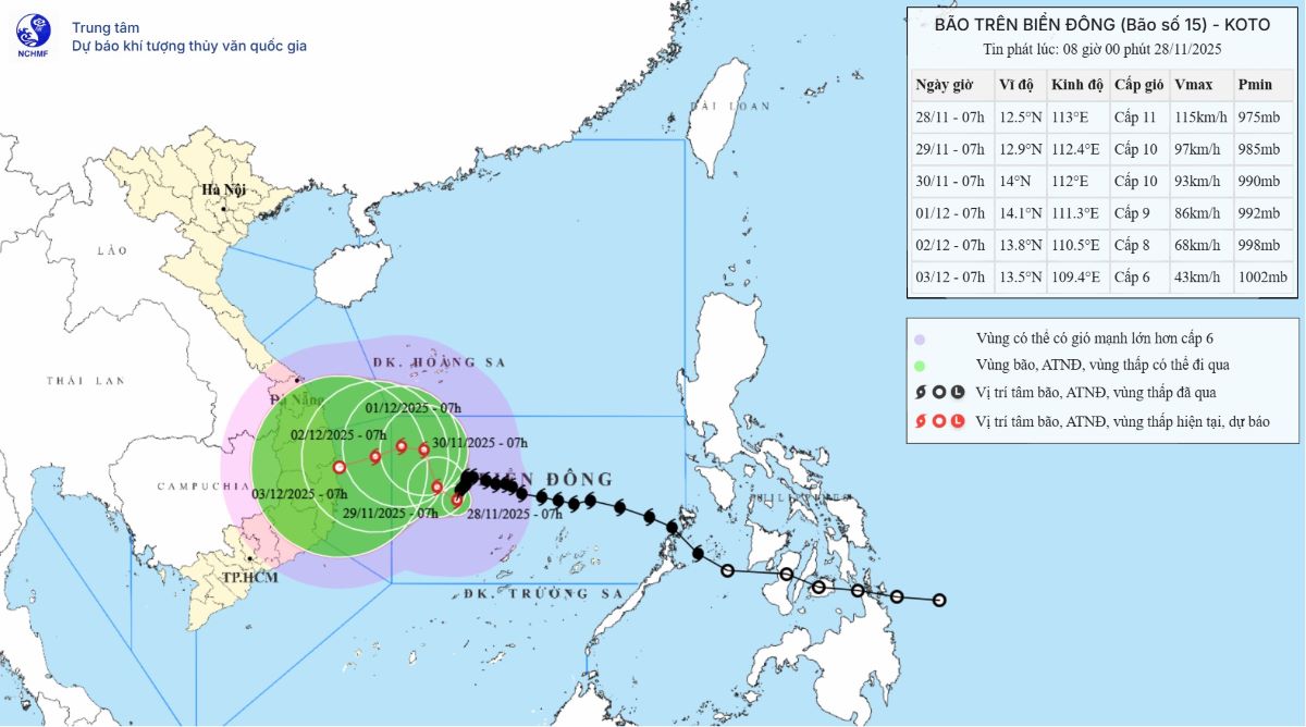
Ngay sau bão số 15, cơn bão Senyar được đánh giá là cơn bão có một không hai trong lịch sử hơn 180 năm qua.
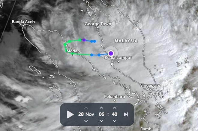
Sau bão số 15, xuất hiện bão Senya. Trong ảnh là đường đi của bão lúc 6h40 ngày 28.11. Ảnh: Zoom Earth
Bão Senyar – hiện tượng khí tượng được đánh giá là “chưa từng có tiền lệ” trên eo biển Malacca – không chỉ lập hàng loạt kỷ lục hiếm gặp mà còn để lại một vùng áp thấp có khả năng tác động trực tiếp đến Biển Đông trong vài ngày tới.
Dưới ảnh hưởng của bão số 15, vùng áp thấp này có thể bị hút ngược ra Biển Đông và mạnh lên trở lại thành áp thấp nhiệt đới vào khoảng ngày 29.11.
Nếu hình thành xoáy thuận mới, đây sẽ là xoáy thuận nhiệt đới thứ 21 trên Biển Đông năm 2025, vượt kỷ lục 20 cơn của năm 2017, qua đó lập kỷ lục lịch sử về số xoáy thuận hoạt động trong 1 năm.
Vị trí và dự báo hướng đi của bão số 15 lúc 8h sáng 28.11. Ảnh: Trung tâm Dự báo khí tượng thủy văn quốc gia Việt Nam
Senyar: Cơn bão “có một không hai” trong lịch sử khí tượng
Bão Senyar tan sau khi đổ bộ vào bờ Tây Malaysia rạng sáng 28.11, nhưng ngay lập tức được ghi nhận là một trong những hiện tượng khí quyển đặc biệt nhất khu vực Ấn Độ Dương – Tây Bắc Thái Bình Dương.
Theo tin bão của Cục Khí tượng Malaysia (MetMalaysia), bão đổ bộ khoảng 1h sáng 28.11 vào giữa Banting và Port Dickson, sau đó suy yếu khi đi vào Pahang, nhưng vẫn gây mưa từng đợt tại nhiều bang do hoàn lưu thấp còn sót lại.
Lý do Senyar gây chấn động giới khí tượng nằm ở hàng loạt kỷ lục mới được xác lập:
Cơn bão nhiệt đới đầu tiên trong lịch sử hơn 180 năm qua hình thành ngay trên eo biển Malacca, khu vực vốn được xem là không có bão. Kể từ năm 1842, chưa từng có xoáy thuận nhiệt đới mạnh nào được ghi nhận tại vị trí Senyar xuất hiện.
Cơn bão đầu tiên được Cục Khí tượng Ấn Độ (IMD) đặt tên tại vị trí này.
Cơn bão có vĩ độ hình thành thấp thứ hai kể từ khi IMD đặt tên bão năm 2004.
Cơn bão đầu tiên đổ bộ Sumatra (Indonesia) trong tháng 11 trong hơn 1 thế kỷ dữ liệu.
Cơn bão có sức gió mạnh nhất khi đổ bộ Sumatra, vượt qua bão Vamei (2001).
Cơn bão có tên đầu tiên đổ bộ Indonesia trong lưu vực Bắc Ấn Độ Dương.
Cơn bão thứ hai trong lịch sử đổ bộ phần lãnh thổ Indonesia thuộc Bắc Bán Cầu.
Cơn bão đầu tiên đổ bộ Indonesia trong tháng 11 kể từ bão 03S (2001).
MetMalaysia nhấn mạnh rằng Malaysia vốn nằm ngoài đường đi của bão nhiệt đới, do đó sự xuất hiện của Senyar là “cực kỳ bất thường”. Cơ quan này tiếp tục phát cảnh báo mưa lớn đến hết ngày 29.11 và theo dõi sát diễn biến của hoàn lưu còn lại.
Vùng áp thấp sau Senyar: Nguy cơ tái sinh thành xoáy thuận trên Biển Đông
Điều đáng lo ngại hơn nằm ở vùng áp thấp hình thành sau khi bão Senyar tan. Vùng xoáy yếu này đang tồn tại phía Tây Malaysia và hiện di chuyển chậm.
Dưới tác động của cơn bão số 15 (lúc 7h sáng 28.11 ở vào khoảng 12,5 độ vĩ bắc, 113,0 độ kinh đông, cách đảo Song Tử Tây khoảng 190km về phía tây bắc), vùng áp thấp có thể bị hút sang phía đông, một hiện tượng lần đầu tiên được ghi nhận giữa hai lưu vực khí hậu Ấn Độ Dương và Tây Bắc Thái Bình Dương.
Các mô hình dự báo bão cho thấy, khi tiến ra Biển Đông, vùng áp thấp này có thể mạnh lên thành áp thấp nhiệt đới trong khoảng ngày 29.11. Nếu điều này xảy ra, đây sẽ là cơn áp thấp hoặc bão thứ 21 hoạt động ở Biển Đông năm nay – con số chưa từng có.


. Source: Adapted from U.S. Geological Survey")